


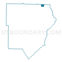
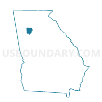
067DV01 - DAVIS 01 Voting District, Cobb County, Georgia
About
Outline

Summary
| Unique Area Identifier | 560757 |
| Name | 067DV01 - DAVIS 01 Voting District |
| County | Cobb County |
| State | Georgia |
| Area (square miles) | 1.07 |
| Land Area (square miles) | 1.07 |
| Water Area (square miles) | 0.00 |
| % of Land Area | 99.90 |
| % of Water Area | 0.10 |
| Latitude of the Internal Point | 34.06844180 |
| Longtitude of the Internal Point | -84.47762880 |
Maps

Graphs
Select a template below for downloading or customizing gragh for 067DV01 - DAVIS 01 Voting District, Cobb County, Georgia


Neighbors
Neighoring Voting District (by Name) Neighboring Voting District on the Map
- 057026 - LITTLE RIVER Voting District, Cherokee County, GA
- 057044 - WOODSTOCK Voting District, Cherokee County, GA
- 067KL01 - KELL 01 Voting District, Cobb County, GA
- 067MB01 - MABRY 01 Voting District, Cobb County, GA
- 067PO01 - POST OAK 01 Voting District, Cobb County, GA
- 067RM02 - ROCKY MOUNT 02 Voting District, Cobb County, GA
Top 10 Neighboring County Subdivision (by Population) Neighboring County Subdivision on the Map
Top 10 Neighboring Place (by Population) Neighboring Place on the Map
Top 10 Neighboring Unified School District (by Population) Neighboring Unified School District on the Map
Top 10 Neighboring State Legislative District Lower Chamber (by Population) Neighboring State Legislative District Lower Chamber on the Map
Top 10 Neighboring State Legislative District Upper Chamber (by Population) Neighboring State Legislative District Upper Chamber on the Map
Top 10 Neighboring 111th Congressional District (by Population) Neighboring 111th Congressional District on the Map
Top 10 Neighboring Census Tract (by Population) Neighboring Census Tract on the Map
- Census Tract 909.02, Cherokee County, GA (13,319)
- Census Tract 303.41, Cobb County, GA (4,395)
- Census Tract 303.26, Cobb County, GA (4,059)
- Census Tract 909.05, Cherokee County, GA (3,908)
- Census Tract 303.40, Cobb County, GA (3,784)
- Census Tract 303.24, Cobb County, GA (3,441)